

Sun-bleached rocks wind through a bush landscape which leads you to the first water filled pool. The backdrop of an amber hued hill reveals a dreamy, reflective…

Adcock Gorge is a picturesque gorge and swimming spot on Mt House station, approximately 5 kilometres off the Gibb River Road. The driving track is 4WD only.

Galvan’s Gorge is the most accessible gorge along the Gibb, located just 1 kilometre off the road. This is a popular and pretty swimming spot, with a small…

Located on Manning Creek in the grounds of the 283,280ha Mt Barnett Station, water remains at the base of the waterfalls and in several pools along the creek year…

The serene surroundings of Emma Gorge waterfall make it a tranquil and relaxing place to swim. An approximate one-hour picturesque walk over rocky terrain rewards…

Adventure Wild Kimberley Tours
Experience the very best of the Kimberley on a 12-day all-inclusive guided safari with…

WA NT TOURS
The West Coast is our home! WA NT TOURS are the specialists for guided small group tours…

Kimberley Safari Tours
Put on your hiking shoes, have your swimming gear handy and get ready for breathtaking…

El Questro Tours & Activities
Spend some time exploring the magical landscapes of El Questro - join a guided walking, 4WD or…

On the Verandah
Join an On The Verandah Kimberley workshop and experience life on a remote cattle…

Inspiration Outdoors
Explore the North West with Inspiration Outdoors Western Australia's North West is a land of…

Kimberley Outback Tours
Kimberley Outback Tours operate multi-day tours throughout Western Australia and the Northern…

Venture North Safaris
Venture North is a multi-award winning, family owned company specialising in micro-group…

APT Kimberley Wilderness Adventures
Explore the Kimberley with the experts, with over 45 years experience and every detail taken…

Kimberley Spirit Tours
Explore Western Australia’s spectacular Kimberley region with Kimberley Spirit tours. Discover…

Outback Spirit
Part of Journey Beyond, a national business focused on bringing Australia’s most unique and…

Ventur Atlas
Explore the Western Australian Kimberley region with Ventur Atlas' exclusive luxury adventure…

El Questro - The Station
El Questro sprawls over 700,000 acres and is one of the world's most unique holiday destinations. El Questro Station sits in the heart of the property with stunning views of the rugged landscape and…

Mount Hart Wilderness Lodge
Nestled in a hidden oasis along the famous Gibb River Road, Mount Hart Wilderness Lodge is a popular base for adventurous travellers. With its unbeatable proximity to many of the region's major…

Mt Elizabeth Station Stay
Mt Elizabeth Station is about as close to the heart of the Kimberley region in Western Australia as you can get. Located roughly half way between Kununurra and Derby on the iconic Gibb River Road, Mt…

Ellenbrae Station
Located 230km from Kununurra along the Gibb River Road, Ellenbrae Station is a much-loved stop for travellers seeking outback charm, shady lawns, freshwater swimming holes — and the most famous scones…

Many of the North West’s incredible natural attractions are located in the spectacular surroundings of our National Parks.

Wunaamin Miliwundi Ranges Conservation Park
Situated on the south-western edge of the Kimberley Plateau along the Gibb River Road, explore…

Dimalurru (Tunnel Creek) National Park
Dimalurru (Tunnel Creek) National Park is Western Australia's oldest cave system. You…

Mitchell Falls & The Mitchell River National Park
The four-tiered Mitchell Falls is an iconic Kimberley attraction, and one of the most…

Bandilngan (Windjana Gorge) National Park
Carved by the Lennard River, Bandilngan (Windjana Gorge) is over three kilometres long with…

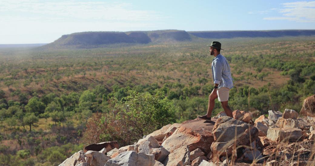
Tackle one of Australia's most iconic outback drives, the Gibb River Road, soaking in all that the Kimberley has to offer.

On this self-drive adventure, experience the 350-million-year old Balili (Devonian Reef) system, the vast and panoramic landscape of the Fitzroy River floodplains…
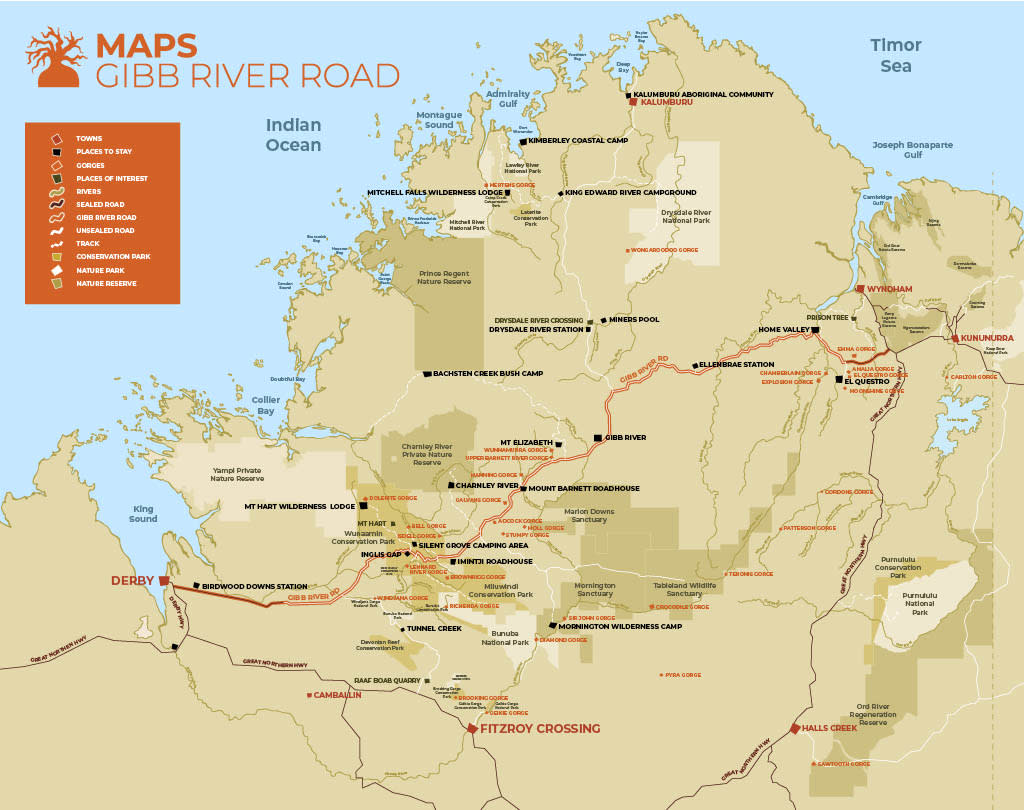
Gibb River Road Map
This map of the Gibb River Road, produced by Derby Visitor Centre is a great planning tool for your Gibb River Road trip. You can find this map in the G.O.A,T Guide to the Gibb River Road from the Kununurra Visitor Centre or in the upcoming West Kimberley Guide from Australia's Boab Country.

Derby
Home of Australia’s largest tides, Derby is a friendly and historic outback town perched…

Mitchell Plateau
Venture off the Gibb River Road on a detour that rewards you with jaw-dropping views of the…

Kununurra
The vast, stunning landscapes, remarkable waterways and lush farmland around Kununurra are…

Wyndham
At the end of the Great Northern Highway you will find the little town of Wyndham, which has…